Frequently Asked Questions about YAAC
- Why won't YAAC start when I click on it?
- What kind of maps can I use in YAAC?
- Why can't I use Google™ Maps in YAAC?
- Why don't I see any maps in YAAC?
- Why does it take so long to install maps?
- Why does my map suddenly jump to somewhere else without me doing anything?
- Why can't I see my packets on the YAAC screens?
- Why is there a big yellow circle on my map around my station?
- Why has my whole map turned dark gray?
- Why does my TNC stop working or not work?
- Why can't my Linux system open the serial port to my TNC/weather station/GPS?
- Why doesn't YAAC understand my GPS receiver?
- Why doesn't the wizard and configuration dialog detect my AGWPE server?
- Why can't YAAC transmit to the Internet or function as an I-Gate?
- Why isn't YAAC working as a transmit-capable I-gate?
- How do I check that my I-gate is working?
- Why isn't YAAC working as a digipeater?
- How do I check that my digipeater is working?
- Why aren't my beacons being transmitted?
- Why aren't any of the Query or Message menus showing up?
- Why isn't my station's time since transmission resetting when I send packets?
- Why are stations and objects disappearing off my screen?
- How do I find a particular station on my map?
- I heard messages from station "X"; why isn't he on my map?
- Why am I seeing "Reaching heap limit" errors?
- How can I file a problem report or enhancement request?
Why won't YAAC start
when I click on it?
There are several reasons why YAAC may not start on a particular
computer:
- The Java Runtime Environment hasn't been installed, or is of
too old a version (older than Java 8) to support YAAC.
- There is not enough virtual memory left unused on the computer to support running
YAAC.
What kind of maps can I use in YAAC?
The types of maps supported by YAAC are both vector and raster maps.
The OpenStreetMap data is vector-based, and can be zoomed to any arbitrary level and seen
just as clearly, because it will be redrawn from scratch at the current zoom level to
look good. Also, YAAC is smart enough to leave out extremely fine details when zoomed out
to cover a large area, and reintroduce those fine details as the map is zoomed in enough
to distinguish those elements.
The U.S. Geological Survey's Shuttle Radar Topographic Mission elevation data
is raster data; as you zoom in, it will start to appear "chunky" as the size of a single
piece of map data becomes a noticeable part of the screen area. Similarly, other raster maps
like the US National Weather Service radar map and arbitrary raster overlays will also
become "chunky" when zoomed in closely.
Why can't I use Google™ Maps in YAAC?
YAAC has been deliberately designed not to depend on any Internet-based
map server as a realtime map data source. It is intended to be usable in situations where the
Internet is not accessible (such as emergency conditions or other field operations), and
therefore only uses mapping capabilities that are self-contained
within the computer running YAAC. Even the weather radar overlay capability stores the current
weather map on the local computer for rendering (and will simply not display the weather map
if it cannot be downloaded).
Why don't I see any maps in YAAC?
You may not have installed any OpenStreetMap or SRTM data on your
computer. Download and import OpenStreetMap data, or copy pre-processed
tiles from the YAAC author's website, or download SRTM terrain data from the
U.S. Geological Survey.
You may have misconfigured the directory for the map tiles to
point to a place where no map tiles exist.
You may not have map tiles for the area of the Earth currently
being viewed in the YAAC map window (for example, there are no streets in
the middle of the ocean, or you may have done only a partial map install). Note that the
area you are viewing may be automatically changed if you receive an APRS packet with
EMERGENCY status, as the default behavior of YAAC in such cases is to pan the map to the
location where that station is located to aid you in providing assistance to that station.
YAAC may have added support for new OpenStreetMap features to the map data provided
on the YAAC author's website, but you are still running an old version of YAAC that does
not support those new features. You will need to upgrade
your version of YAAC.
You may have turned off displaying geographical maps in the
View->Layers->Select Geographical Map Layers dialog.
Why does it take so long to install maps?
OpenStreetMap data is enormous, since it provides street-level map
data for the entire planet. As such, it takes time to analyze all
that data and convert it into efficient map tiles.
However, YAAC's author periodically converts the current OpenStreetMap data
into YAAC tiles and makes it available for download on his website using the File->OpenStreetMap->Download Pre-Imported Tiles
menu choice, which is significantly faster than downloading amd importing the original compressed XML or PBF file
and doesn't require any later processing because it has already been processed. So, unless you
need OpenStreetMap data that is more recent than what the author has provided,
or for some reason have to use an old version of YAAC that does not support current tile formats,
we recommend you just download copies of his tiles.
The U.S. Geological Survey has "throttled" their website to protect against Denial Of Service attacks.
As such, YAAC must download their SRTM files one at a time to prevent being blocked as an attacker.
To help in detecting emergency situations, when YAAC detects a station reporting emergency status,
it will automatically pan the map to center on the reporting station and briefly display flashing red arrows
pointing at the station. This will happen whenever a station is reporting emergency status in one of
three ways:
- transmitting Mic-E format position reports with the status code for emergency.
- transmitting any APRS message with the literal text "EMERGENCY" (without the quote marks) in the
free-text comment.
- transmitting OpenTRAC protocol messages with the Emergency field in them.
Note that this may cause some false alarms, as some stations are reporting that they are located at
an EMERGENCY OPERATIONS CENTER or EMERGENCY MEDICAL SERVICES (rather than using the abbreviations EOC and EMS), when they are not actually at emergency
status. As such, please do not use that word in your comments or select Mic-E emergency status unless
you really mean you have an immediate emergency regarding life or property that needs someone else to
respond to it.
If there are misconfigured stations in your region that still insist on reporting
emergency status when they do not have an emergency, you can turn off the auto-pan
feature on the expert-mode Configuration dialog's Behavior tab.
Note that, except for the Outgoing Messages window, YAAC only displays APRS traffic that your
station receives, not what it transmits. So you will not see any traffic originated by
your station except, if you are listening on RF, any packets that a local digipeater repeats
back to you. The APRS-IS Internet servers never send back any packets that your station sends
to them.
This big yellow circle identifies your Aloha range, which is the maximum distance your station can safely transmit
directly over RF without saturating the RF channel (i.e., reaching too many digipeaters). It is a function of the station
density (number of transmitting APRS stations) in your local vicinity on the same channel, the number of those stations that are digipeaters,
and the number of other objects and items reported in your area on that channel. The Aloha range is drawn as a dashed yellow circle if your station has not
heard enough other stations and objects to estimate the Aloha limit, or a solid circle at the Aloha limit. The Aloha limit
is an approximation, based on assumptions about recommended transmission rates for different types of stations,
and assuming equal omnidirectional propagation; it does not use terrain data or actual transmission rates
to adjust the calculated range. Note that if your PHG-estimated or actual range exceeds the solid Aloha circle,
you may wish to lower your antenna or reduce your power output to prevent channel congestion.
For further information, consult WB4APR's discussion on the subject at http://aprs.org/aloha.html.
One of the optional parts of the map display is the ambiguity circles. These plot the area a station could
be in, given the possibly coarsened resolution of its position information.
Some APRS applications (including YAAC) do support dropping the finest resolution
digits of the position data. If you select the View->Layers...->Show Ambiguity option, these circles
will be displayed as translucent ovals in the most common color of the icon image for the station.
The problem occurs when dead-reckoning is also enabled,
and a rapidly moving mobile station shuts down without transmitting a final position with zero speed
(or simply goes out of range). The ambiguity circle
is automatically enlarged to account for the last reported speed of motion, since YAAC will not know the
actual current position of the mobile station until it beacons again. As such, the ambiguity circle for the station
will continue to grow until the dead-reckoning timeout. Since airplane icons are in dark gray, and the car icon is
outlined in black, both can cause gray circles to grow to cover the screen if YAAC loses reception of the beacons while the
other stations are still moving rapidly.
Why does my TNC stop working or not work?
There are several possibilities for this.
- Some TNCs that support both command mode and KISS mode do not remember or persist their mode
setting. If the power to the TNC glitches, or the TNC reboots for some other reason, it may switch
back to command mode, which is not supported by YAAC. YAAC will eventually detect that data is
coming from the TNC in the wrong mode (assuming the TNC is still receiving traffic), and will
attempt to switch the TNC to KISS mode again (assuming that YAAC was configured to automatically
switch the TNC from command mode to KISS mode to begin with).
- The configuration for the TNC port must specify a valid callsign (optionally with a SSID
between 1 to 15). NOCALL is not a valid station callsign and will be rejected; a blank callsign
is also not acceptable.
- Some TNCs cannot handle high data rates from YAAC, and will crash if you send traffic from
YAAC faster than the TNC can handle it.
 Some TNCs (including Kenwood D700/D710 transceivers with built-in TNCs) require hardware flow control
to be enabled on the RS232 serial port used to communicate with the transceiver; this hardware flow
control meters the rate at which new data can be sent to the TNC to prevent overflow. For hardware
flow control to work correctly, ensure that your computer serial port supports modem control signals
(some USB-to-RS232 adapters do not) and you have a RS232C serial cable with more wires than just
signal ground, TxD, and RxD (the additional lines needed are RTS, CTS, and DSR), and that
you have selected hardware flow control in YAAC. Note that unplugging the cable will also cause this failure.
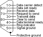
The DSR (Data Set Ready) signal is used to detect that there actually is a TNC connected to the port,
whereas the RTS (Request To Send) signal indicates that YAAC wants to send something and CTS
(Clear To Send) indicates the TNC is ready to accept it.
Some TNCs (including Kenwood D700/D710 transceivers with built-in TNCs) require hardware flow control
to be enabled on the RS232 serial port used to communicate with the transceiver; this hardware flow
control meters the rate at which new data can be sent to the TNC to prevent overflow. For hardware
flow control to work correctly, ensure that your computer serial port supports modem control signals
(some USB-to-RS232 adapters do not) and you have a RS232C serial cable with more wires than just
signal ground, TxD, and RxD (the additional lines needed are RTS, CTS, and DSR), and that
you have selected hardware flow control in YAAC. Note that unplugging the cable will also cause this failure.
The DSR (Data Set Ready) signal is used to detect that there actually is a TNC connected to the port,
whereas the RTS (Request To Send) signal indicates that YAAC wants to send something and CTS
(Clear To Send) indicates the TNC is ready to accept it.- Or it might be something the YAAC author does not know about. Contact your TNC manufacturer
for further support.
- If the serial port can't be opened, it could be because some other
application is using the serial port. Serial ports cannot be shared between applications. Even on
Linux using the legacy RXTX serial port drivers (not recommended unless on an operating system not
supported by the JSSC library), although the port open may work, the port may be unusable if
another application is stealing bytes from YAAC.
Why can't my Linux system open the serial port to my TNC/weather station/GPS?
Linux and other Unix-based operating systems have fine-grained access control to prevent random users from accessing physical hardware devices
and possibly interfering with proper system usage. As such, the account you are using to run YAAC
must be authorized read/write access to the appropriate serial port devices (/dev/ttyXXXX files)
before YAAC can open the devices. Typically, this requires that your login account be a member of the Unix
group that owns the serial port devices (usually called "dialout", "tty", or "uucp").
Have your system administrator grant your account memberships in this group, and the
problem should go away. The typical administrative command to do this is (must be done as root):
usermod -G dialout -a yourusername
Note you will have to log out and log back in again for the new group memberships to take effect.
Another possible cause of the problem is running YAAC on a non-Intel-CPU computer. The JSSC library used
by YAAC to access serial port devices requires native machine code, and YAAC only ships with the JSSC native code
for a few operating systems (Microsoft Windows 32-bit and 64-bit, Linux 32-bit and 64-bit on Intel processors,
Solaris on Intel processors, Apple Macintosh OS X 10 32-bit and 64-bit) on Intel-compatible CPUs, and ARM
processors (Linux O/Ss using both soft-float and hard-float). For other CPUs (such as the Sun SPARC processor)
and operating systems (such as FreeBSD), you will need to manually install your operating system
distro's version of JSSC; if this does not work, contact the YAAC author with a bug report,
so he can add knowledge of your operating system's specific location of its build of JSSC into YAAC.
For other operating systems that do not include JSSC in their distro, you may have to
download the latest version of JSSC source
code, and compile and install JSSC yourself; consult your operating system's documentation.
Why doesn't YAAC understand my GPS receiver?
There are several reasons why YAAC is receiving garbled data from your GPS receiver instead of
proper NMEA-0183 sentences:
- You have the baud rate set incorrectly. Although most GPS receivers default to 4800 baud,
some use other baud rates (usually faster so that more information can be sent to the computer).
Check that the baud rate is correct for your GPS receiver.
- The GPS receiver is using its manufacturer's proprietary binary protocol instead of
NMEA-0183 ASCII protocol. Rockwell and SiRF are among the manufacturers who have custom binary
protocols providing more features than NMEA-0183, but YAAC does not support any of these
protocols. YAAC does know enough to issue the SiRF binary protocol command to switch back
to NMEA-0183 protocol.
- If you are on a Linux or Unix system, you may have the gpsd daemon installed. If so, the
gpsd software generally starts up at system boot time and grabs ownership of all connected GPS
and other types of navigation receivers. It does not lock the serial port device file, nor does
it honor locks placed by other software (such as YAAC); hence gpsd and YAAC will alternately
grab characters from the GPS serial port, leaving each with only partial data. There are
two solutions for this:
- Uninstall gpsd. This prevents it from automatically grabbing control of GPS receivers,
but also eliminates the ability to share GPS receivers between YAAC and other applications.
- Stop using the Serial_GPS driver in YAAC and access the GPS receiver through the GPSD
driver instead, taking advantage of gpsd instead of fighting with it.
Note that gpsd will automatically switch a supported GPS to its binary protocol if that is more
efficient than using NMEA-0183; however, it does not undo this switching when gpsd is shut down. As
such, moving a GPS receiver between gpsd and direct YAAC access may not work if the GPS has been switched.
Consult the GPS manufacturer's documentation to determine how to switch the GPS receiver back to
ASCII NMEA-0183 mode. If you plan to move a GPS receiver between gpsd and applications requiring
NMEA-0183 regularly, it is recommended to run gpsd with the -b and -n
options to prevent it from switching the GPS receiver to binary mode.
Why doesn't the wizard and configuration dialog detect my AGWPE server?
- The AGWPE server process may not be running; if it isn't alive, YAAC can't communicate with it.
- The AGWPE server process may be configured to listen for APRS clients on a non-default TCP port
number. By default, YAAC expects to see AGWPE running on TCP port 8000, but expert-mode configuration
can change the AGWPE port number.
- YAAC may be configured for the wrong port name within the AGWPE service, due to renaming the port
within AGWPE.
- Regardless of whether the AGWPE server is running, YAAC won't connect to it if the
callsign is not specified for the YAAC port.
Note these comments also apply to other software that emulates AGWPE, such as DireWolf and UZ7HO soundmodem.
Why can't YAAC transmit to the Internet or function as an I-Gate?
It can. To access the APRS-IS backbone, you need to open a port of type APRS-IS, get a valid passcode
for your callsign (contact the YAAC author), and enable the port for transmission.
An I-Gate is a digipeating station that relays APRS packets between the APRS-IS backbone and local RF.
As such, it needs both a transmit-enabled APRS-IS port to connect to the backbone, and an RF port
(such as Serial_TNC or AGWPE) with a radio to be able to hear and transmit to other local RF stations. For
more information, read this tutorial on YAAC I-gating.
If you don't see stations appearing in the Show TX IGated Stations table view, there's
probably a good reason for it. Note that stations will only appear in this table if all of the below conditions are met:
- Both your RF and APRS-IS ports are transmit-enabled, and forwarding in both directions is checked on the expert-mode
configuration dialog's Transmit tab.
- Either:
- You have I-gated some RF-local station to APRS-IS, and
- Some other station has attempted to contact that RF-local station over APRS-IS.
or you have a supplemental Tx I-Gate filter that approves
forwarding the specific packets.
Once all of those conditions are met, the second station will appear in your Tx-I-gate table as a station that your
station has forwarded to RF (and you will have recorded the packet with your third-party wrapper in your transmit log
file as being sent to your RF port).
To truly test a YAAC receiving I-gate, you need to use an RF station close to your I-gate that can't be heard
by any other nearby I-gate; an HT on low power makes a good test source. This way, there won't be any
competing I-gate to beat YAAC to the backbone. You can then look on aprs.fi for your low-powered station's
packets. Confirm that the digipeat path specifies ",qAR,your-igate-callsign", which will indicate
that your I-gate was the station to forward the packets to the APRS-IS backbone.
There are four pre-requisites that have to be configured correctly before YAAC can function as a
digipeater:
- On the Digipeat tab of the expert-mode Configure dialog, confirm that the aliases you wish
to digipeat for are present (i.e., recognized by YAAC) and their enable checkbox is checked.
This is the overall control for those digipeat aliases.
- On the Ports tab of the Configure dialog, you actually have some ports that support RF,
such as the Serial_TNC or AGWPE types, and such ports are enabled.
- On those ports, in the individual port configuration editing dialog (as launched by the Edit button
on the Ports tab, or by clicking the blinkenlight for the port on the map toolbar), the port is
enabled for transmission.
- Also on those ports, the desired digipeat aliases appear in the "Digipeats for port" list,
and have their checkbox checked (enabling that specific alias on this specific port). The reason for this
selectivity is to support cases such as cross-band VHF-to-HF APRS gateways, where you do not wish to clog the
worldwide HF APRS frequency with the VHF traffic at four times the available HF bandwidth (or worse).
Also, is your radio correctly connected to the TNC or sound card (as appropriate)? YAAC can send frames
to the TNC all it wants, but if the TNC can't push the radio's Push-To-Talk switch, it will never transmit.
How do I check that my digipeater is working?
To test a digipeater, you need an RF station configured to use the digipeat aliases your digipeater supports
that will also report when it hears its own transmissions come back to it (the Kenwood APRS radios work well
at this, or another station using YAAC). Again, have your test station transmit at low power near the
digipeater to be tested, so no other digipeater can preempt the digi under test. Check the digipeat path
when the beacon is received back and see who the first digipeater is. Note that the digipeater must be
configured to TRACE (insert its callsign into the digipeat path as used) to confirm it as the digipeating
station using this technique.
Why aren't my beacons being transmitted?
You may not have enabled beaconing (the Enabled checkbox on the Beacon tab
of the expert-mode configuration dialog).
You may have specified GPS-based beaconing, and there isn't a GPS receiver
port defined, or the GPS receiver is not currently producing a valid position
fix.
You may not have enabled any TNC or APRS-IS ports for transmitting.
The particular beacon may not be selected for any TNC or APRS-IS ports. Multiple beacons
can be defined to identify the station differently on the different ports of a cross-band digipeater
or I-gate.
You may have set your beacon initial rate to 0, which specifies beaconing only by explicit
manual command. Note this is required in some operating modes (such as HF APRS on the 60-meter band
channels in the United States). Note that manual-only beaconing is separately
configured per beacon if you have multiple beacons defined.
The age displayed below the callsign for each station on the map, and in the Station/Object view, is
not the time since the station last transmitted a message; it is the time since YAAC last received
a message from that station or about that object/item. As such, you will not see an age (or it will not
reset to zero) if you are not receiving messages from that station. That includes your own station;
if you are not hearing RF digipeaters echoing your station's packets, you will not see an age reset
to zero (i.e., you just heard something). Note you will never hear your own station through your own
APRS-IS connection.
For you to be able to send a query or a message to another station, you have to be able to transmit
APRS packets. As such, you must have at least one port defined that
is enabled to transmit APRS, such as a Serial_TNC port to RF, or an APRS-IS port to the Internet backbone.
These menu choices are not displayed if you don't have the capability to implement them. Note that the
menu choices will not automatically appear because you have added or modified such a port; you will have
to restart YAAC, so that the port definitions exist at the time the menus are created.
Note also that the standard APRS "broadcast" queries, which search for all stations of a particular type
within communications range, are restricted to RF usage only. APRS-IS only YAAC deployments must not
and will not issue these queries because every station on the planet would be obliged to answer you.
Why are stations and
objects disappearing off my screen?
Either you have changed filter options to stop showing those
stations, or the station/object information has exceeded the
configured maximum age before the station is discarded. See the
Miscellaneous tab in the Edit Filter dialog or the
General tab in the expert-mode Configuration dialog to
change the expiration time.
How do I find a particular
station or object on my map?
Click the Locate menu and select "Station or Object". You can enter the
callsign, or select it from the drop-down in the displayed dialog
box. Then click OK and the map will center on the location of the
station (or former location for expired data) and flashing green
arrows will highlight the station's most recent location (if it
exists).
You can also double-click the mouse on the station or object's row in the Station
Status or Object Status tables (as appropriate).
I heard messages from
station "X"; why isn't he on my map?
The station may not have transmitted position information yet.
Until it does, the station will be plotted on the map with a
"vicinity location", randomly near the first digipeater to
hear it. If that digipeater has not provided position information
either, the station will be displayed at latitude/longitude (0, 0)
(off the western coast of central Africa) until such a time as position
information for the station is received. The
 button will pan the map to (0, 0)
so you can see the non-located stations.
button will pan the map to (0, 0)
so you can see the non-located stations.
YAAC is running out of available memory to store all its data, and is trying to compensate for
the over-demand. This topic gives you several suggestions for dealing with the problem.
There are several ways to report an issue with the YAAC software or request a feature enhancement:
- Join the yaac-users@groups.io mailing list and send an email there. Note this
is probably the fastest means, as some other user may have dealt with your problem already, so you
might get an answer without having to wait for the YAAC author to respond. Or the answer might be in
the mailing list archives.
- Send an email directly to the author. His email address is on his website https://www.ka2ddo.org
- File a trouble ticket on the YAAC page on SourceForge. The URL
is https://sourceforge.net/p/yetanotheraprsc/tickets/
- Ask a question on the discussion forums on SourceForge for YAAC at
the URL https://sourceforge.net/p/yetanotheraprsc/discussion/.