YAAC supports topographic data rendered from the NASA Digital Elevation Model. The NASA Digital Elevation Model data is retrieved from the online Data Pool, courtesy of the NASA EOSDIS Land Processes Distributed Active Archive Center (LP DAAC), USGS Earth Resources Observation and Science (EROS) Center, Sioux Falls, South Dakota, https://www.earthdata.nasa.gov/data/tools/lp-daac-data-pool. A downloader is built into YAAC for your convenience. All you have to specify what area of the planet you want to download, and YAAC will do it for you. Note you must have connectivity to the global Internet for this to work, and an account on the NASA Earthdata data pool web service. If you do not already have such an account, go to the User Registration Site for Earthlink to create your free account, and then request access to the LP DAAC Data Pool application.
Upon selecting the File->Topographic->Download Tiles option, a dialog box will be displayed showing what map data (if any) you have.
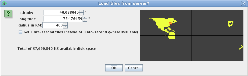
The dialog shows yellow dots where you have data downloaded, and dark gray dots where you do not. The red box identifies the area that will be downloaded should you choose to proceed. You can move and resize the red box by changing the center latitude and longitude parameters, and the radius parameter.
You can also choose to download higher resolution (1-arc-second) topographic data. Currently, this data is only available for the United States and its territories. Note the higher-resolution data will take up approximately 9 times as much disk space as the default 3-arc-second data that is available world-wide, and will also take longer to render topographic information on the map. Choose this only if you have a need for such precision data (such as for Search and Rescue operations).
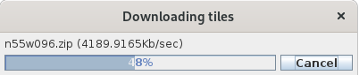
If you click “OK”, YAAC will bring up a progress dialog reporting how far through the download process you are and which file it is downloading at any given point in time, then prompt you for your Earthdata login credentials. The progress dialog will automatically go away when the download is complete. Note that, if you stop YAAC in the middle of the download, you will only have what was successfully downloaded up to that point. You can also prematurely cancel the download by clicking the “Cancel” button on the progress dialog. Note the cancel will wait until the current tile file is complete before actually stopping.
Once the topographic elevation data is downloaded, you can choose how to display it from the View->Layers...->Show Topography menu choice, or use the elevation data in generating line-of-sight plots.