Incoming message traffic can be displayed in several ways in YAAC. These include the default geographical map display, the raw messages in text, binary, or decoded, lists of active stations and tracked objects, and specially addressed text messages.
The geographical map display is the default main window of the YAAC user interface.
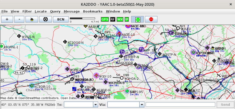
It consists of a toolbar below the main menu bar, the actual map, and a current position indicator and message sending area below the map. The map itself consists of multiple superimposed layers of information, including a geopolitical map background rendered from OpenStreetMap data, ground elevation contours, user-provided raster map images, arbitrary drawn lines, and icons representing active stations and objects whose tracking information has been received by YAAC. The different layers can be selectively enabled and disabled by options on the View menu.
The map may be zoomed in and out by clicking the + and - buttons above the map, or by pressing the + and - keys on the keyboard while the map window has focus. The map may also be panned to be centered on the location of this station (the "home" button) or to latitude/longitude (0,0), where all stations whose location cannot yet be determined or estimated are plotted on the map. A button is also provided to force sending the station beacon immediately. The current map scale is displayed to the right of the buttons. To the right of the scale are displayed activity indicators for all defined interface ports (TNC, APRS-IS, GPS, weather station), followed by a optional heap memory usage meter and a button to "freeze" message reception (useful for analysis when messages are arriving at a very rapid rate).
The map also be panned in any direction by pressing the left mouse button on the map and dragging the map in the desired direction; if the shift key is held down while dragging the mouse, this will outline a region of the map that should be zoomed to when the mouse is released. The keyboard's arrow keys can also pan the map 10% of the map size in whichever direction the arrow specified (left arrow to pan left, etc.). If you right-click the mouse on the map, a context-sensitive menu appears specifying commands that may be executed for that position on the map.
The Raw Packets window displays the raw AX.25 packets in a tabular format. The table is updated in real-time as new packets arrive, and may be filtered to show only selected messages using the Filter menu. It may also be sorted by any of the columns in the table by clicking the column header for the desired sort key.
The currently known list of transmitting stations and objects may be displayed as a table view of current status of each station or object. Double-clicking on a row of the table view will automatically pan the map to center on the selected station or object.
The status of the attached GPS receiver or weather station (if any) may be displayed in another window.
Text messages directed to specific stations or broadcast to groups or the general amateur radio public may be displayed in the message windows. There are three different views for messages:
The amount of network traffic passing through any interface port configured in YAAC may also be monitored with a real-time bandwidth performance monitor.